
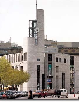
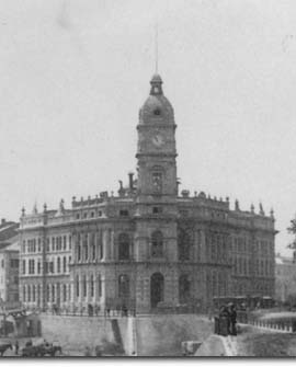
 Designed by architect Dan S. Hanganu and built in 1992, the "Éperon" building is reminiscent of the Victorian structure that formerly stood on this spot, the Royal Insurance Company Building, shown here in a photograph by A. Henderson, circa 1870 (detail). Hanganu has won several prestigious architectural awards for this remarkable contemporary integration of old and new. The lookout offers a superb view. The main entrance of the Museum rises above the point of land where Paul de Chomedey, Sieur de Maisonneuve, Jeanne Mance and other French settlers landed in 1642. Here, on this spot between the St. Lawrence and the Little St. Pierre River (now channelled underground), this small group raised the Ville-Marie fort, the first buildings of Montréal. The remains of the cemetery established near the fort can still be seen in the Museum.
|
Here you are at the very birthplace of Montréal, where Pointe-à-Callière, the Montréal Museum of Archaeology and History, opened in 1992 to protect and display the remains of the colony's early days.
|
| Home | Site map | Contact us |
Credits. All rights reserved, 1998-2001.
|