HomeSite mapContact-us
Saint-Paul and de la Commune


Tour route Next section Previous section Back to Notre-Dame Est Boulevard Saint-Laurent Rue Notre-Dame West The Old Seminary and Notre-Dame Place d’Armes Rue Saint-Jacques Des Récollets Around Rue de l’Hôpital Rue Saint-Paul, near Place d’Youville Place d’Youville Western end of the Old Port Pointe-à-Callière and Place Royale Saint-Paul and de la Commune From Saint-Amable to Saint-Gabriel Place Jacques-Cartier Eastern end of the Old Bonsecours From Bonsecours to Berri Rue Notre-Dame East Champ-de-Mars

Rue St-Paul


Where city meets port

Before and after 1850

A remarkable complex


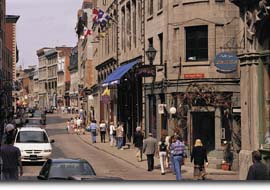
Now we are on Montréal's oldest street. Here, at the confluence of the city and the Port, warehouse-shops once welcomed customers through their front entrances on Rue Saint-Paul and brought in goods through their back doors on de la Commune.

Art galleries, shops, restaurants, shows at Deux Pierrots... Rue Saint-Paul has regained its former vibrant character with the rediscovery of Old Montréal.

Detailed neighbourhood map

Top of page

| Home | Site map | Contact us |

Old Montréal

Credits. All rights reserved, 1998-2001.
Last updated:
January 2003