HomeSite mapContact-us
Place d’Youville


Tour route Next section Previous section Back to Notre-Dame Est Boulevard Saint-Laurent Rue Notre-Dame West The Old Seminary and Notre-Dame Place d’Armes Rue Saint-Jacques Des Récollets Around Rue de l’Hôpital Rue Saint-Paul, near Place d’Youville Place d’Youville Western end of the Old Port Pointe-à-Callière and Place Royale Saint-Paul and de la Commune From Saint-Amable to Saint-Gabriel Place Jacques-Cartier Eastern end of the Old Bonsecours From Bonsecours to Berri Rue Notre-Dame East Champ-de-Mars
Place d'Youville, circa 1910 

New and improved
The redevelopment of Place d'Youville, which started in the section now known as Place de la Grande Paix, highlights its many links with the past.


Detailed neighbourhood map 

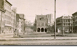
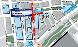
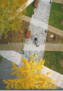
In this part of the tour, you can see traces of every period in Montréal's history. At the heart of this section is a public square which will be redeveloped at the beginning of the 21st century, and the Centre d'histoire de Montréal, updated in 2001.

Place d'Youville, new and improved 

Centre d’histoire de Montréal 

18th-century hospital,
19th-century businesses 

Warehouses from the 1820s 

From 1844 to 1849,
home to Canada’s Parliament!
 

In the midst of a metropolis

Top of page

| Home | Site map | Contact us |

Old Montréal

Credits. All rights reserved, 1998-2001.
Last updated:
September 2001