
|
... and came down Montréal's fortifications were never put to the test. In any case, they would not have prevented the British from taking the city in 1760. Eventually they became a nuisance for the growing town and were demolished in the early 19th century, as set down in a plan prepared by the Commissioners responsible for removing the fortifications. The plan also described the layout of the Champ-de-Mars ("field of Mars") and some new streets around the edges of the old town.
|
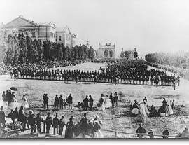
The newly levelled Champ-de-Mars was used as a military parade-ground, a favourite walk for Montrealers and a meeting-place. In 1885, huge numbers of people gathered here to denounce the hanging of Louis Riel, head of the Métis rebels in the Northwest. In 1990, a huge crowd came to cheer on Nelson Mandela, leader of the struggle against apartheid in South Africa. |
| Home | Site map | Contact us |
Credits. All rights reserved, 1998-2001.
|