HomeSite mapContact-us
Place d’Armes


Tour route Next section Previous section Back to Notre-Dame Est Boulevard Saint-Laurent Rue Notre-Dame West The Old Seminary and Notre-Dame Place d’Armes Rue Saint-Jacques Des Récollets Around Rue de l’Hôpital Rue Saint-Paul, near Place d’Youville Place d’Youville Western end of the Old Port Pointe-à-Callière and Place Royale Saint-Paul and de la Commune From Saint-Amable to Saint-Gabriel Place Jacques-Cartier Eastern end of the Old Bonsecours From Bonsecours to Berri Rue Notre-Dame East Champ-de-Mars
Place d’Armes


A long history

Skyscrapers since 1888

People and emotions since the beginning


Detailed neighbourhood map

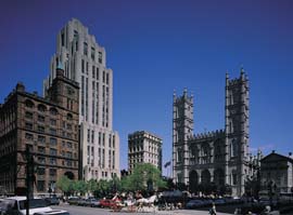
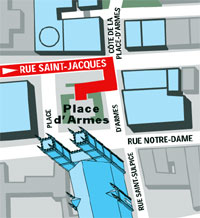
Place d'Armes, the veritable heart of the city, offers a striking historical panorama. Here all the periods of Montréal's past are gathered in one place, around a monument dedicated to the city's founders. This section features the oldest standing building in Montréal, the huge church of the city's mother parish, the head office of the country's oldest bank, the city's first skyscraper... and the generations of skyscrapers that followed.

Clock

(See also sections 15 and 17)

Top of page

| Home | Site map | Contact us |

Old Montréal

Credits. All rights reserved, 1998-2001.
Last updated: September 2001