 |
Discovering
the Fortifications
of Montréal…
… And its
Building Sites
|
|
|
|
|
Discovery
Tour of Old Montréal’s
Archaeological Sites |
|
|
| |
| |
| |
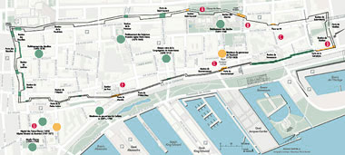
| Clicks on maps for complete
version |
|
The sites depicted on this map illustrate
the enclosure wall and the main buildings of the 18th-century
fortified city. All of these structures are located within,
or immediately outside, the city limits on the side facing
the St-Laurent River. These sites were chosen because remains
were already discovered there, or because there is a good
chance of accessing and excavating more remains without
major obstacles.
Some of the remains of the stone fortifications were unearthed,
in situ, at Parc du Champ-de-Mars, at Pointe-à-Callière,
Montréal Museum of Archaeology and History, and at
Les Remparts Restaurant on rue de la Commune. |
|
 |
| References:
CHARBONNEAU, André, Yvon DESLOGES and Marc
LAFRANCE
Québec, 18th-Century Fortified City. Québec
1982.
LAMBERT, Phyllis and Alan STEWART
(Dir.).
Montréal, 18th-Century Fortified City.
Canadian Centre for Architecture, 1992.
|
|
|
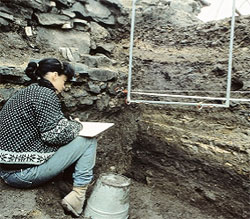 |
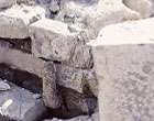
| Archaeological recording.
Photo: Ville de Montréal |
| |
| |
|
 |
 |
 |
|
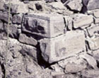
| Champ-de-Mars site, bush-hammered stones
and pieces of metal. Photo: Ville de Montréal |
|
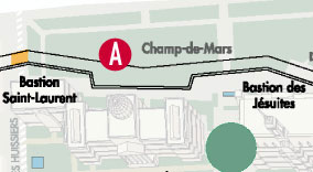
A
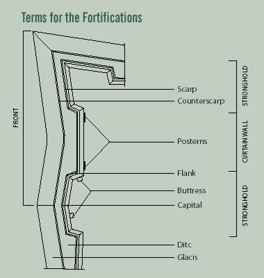
Parc du Champ-de-Mars—This is the only public space
in Old Montréal where we can discover, in situ,
the remains of a complete front from the 18th-century enclosure
wall. The scarp—the inner wall or slope of a ditch, the
counterscarp—the outer wall of a ditch; and the ditch itself
are exposed along more than 250-metre which encompassed half of
the Saint-Laurent stronghold to the west, and the Jesuit stronghold
to the east. These elements exemplify a complete fortified front
and demonstrate the rules of symmetry governing the construction
of a fortified wall. Pieces of metal set in stone and linked to
the door fastening system were found in two posterns. Vaulted
passages carved into the scarp were reserved for military use. |
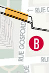
| B
Rue Gosford—The scarp and counterscarp of the Jesuit
stronghold can both be seen here. |
 |
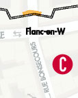
C
Rue Bonsecours—
This W-shaped flank is a type of layout
caused by constraining topography in the construction of a fortification.
In this case, the area between the citadelle and the marsh below
is problematic.
|
 |
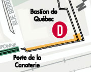 |
D
Rue de la Commune, stronghold of Québec—At
the Faubourg Québec, we find the archaeological remains of
the fortification and the military quarter: warehouses, barracks
and the King’s stores.The King’s “Canoery”,
where canoes were crafted, was built in 1709 and was the site of
a recent archaeological excavation. |
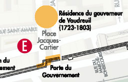
| E
Place Jacques-Cartier—The remains of both
the government stronghold ands the residence of the Governor of
Vaudreuil (1723-1803) are marked in the ground here. Archaeologists
unearthed one house, its outbuildings, latrines, gardens, orchards
and a street. In 1672, the door of Government House opened directly
onto rue Saint-Charles (Place Jacques-Cartier East), and a steep
embankment ran along rue Saint-Paul. |
 |
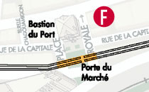 |
F
Dating back to 1676 and a stronghold of the Port, Place
Royale, rues Place-Royale East and West constituted Montreal’s
first public place. The position of the scarp, the supporting wall
of the terreplein—a level space used to mount a battery
of guns—and the terreplein itself, are all visibly
marked on the ground. The market door,which opened onto the river
was also located here. |
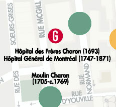
G
Hôpital Général de Montréal
(1693-1871), rue Saint-Pierre —The hospital occupied a large
4.5 hectare tract of land outside the walls at Pointe à
Callière, and touched the shores of both the Saint-Pierre
(Place d’Youville) and St-Laurent Rivers. This important
building complex consisted mainly of a church—part of which
still stands west of rue St-Pierre—a convent, a washing
house, a windmill, gardens and cemeteries. Some remains of the
church and the wing for the poor can both be seen on rue Saint-Pierre.
|
 |
|